
"BAEKDU-DAEGAN" The logo for the ridge, which appears on all the newly built monuments and plaques along the trail.
Saturday again and we're in Gimcheon city, North Gyeongsang province, about 200km into the journey.
Its been a difficult week weather-wise starting on Sunday night with the arrival of Typhoon Nari, which ripped through Cheju Island and brought a lot of rain into the mountains.
Luckily we'd seen the news and were safe in a Minbak (guesthouse), at Sosa-jae pass, 10km north of Dogyu-san national park. We've stayed in a few minbak over the past couple of weeks, but the one at Sosa-jae will be remembered. From the trail it looked like a pleasant country home, but we were led to a basement room which backed onto the chicken and rabbit hutch and had active beehives on either side of the door. Not ideal but the rain was biblical so we paid the ambitious price for the room and saw the storm out with beer and scrabble, which Roger has taken a possibly unpassable 11-2 lead in (largely due to the fact that my casio digictionary equipped with the "Oxford advanced learners dictionary", the judge of all disputes, includes every vulgarity in the english language but precious few of the scientific terms which form the basis of my natural game).

Sambong-san, from Sosa-jae (pass) village.
Monday morning we woke to clear skies in Sosa-jae and climbed over the peaks of Samdo-bong (1250m) and Daedeok-san (1290m) on the way to Deoksan-jae (pass).

Baekdudaegan monument at Deoksan-jae(pass).
Deoksan-jae has a huge, new obelisk Baekdu-daegan monument. In the past 2 weeks we have noticed these structures on most passes and notable peaks along the trail. They have all been erected in the past year.

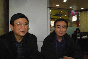
Mr.Kim Yong-won of Hae-in sanjang and Roger.
After a fine day Monday we woke to more rain Tuesday and began a huge day of walking northward to Samdo-bong (1172m) where we planned to camp on the summit. By the time we got there the weather had developed into a full on storm so we dropped off the ridge and spent the night in the home of Mr.Kim Yong-won in the village of Hae-in. Mr.Kim is an accomplished mountaineer who has climbed in many different countries. In 2003 he led the "Korea Youth Wild Places Expedition" to Kenya. He has also climbed Baekdu-san, the great mountain on the Korean/Chinese border, and the unreachable end of this ridge we're walking. Mr.Kim climbed Baekdu-san in the middle of winter, from the Chinese side of course.
Mr.Kim's home, Hae-in Sanjang, is an organised clutter of mountaineering tools, photos, books and his handmade walnut furniture. He offers accomodation year round and in the summer has barbecue tables in the mountain stream which flows around the house. At other times his 83 year old mother, who smokes 6 inch long cigarrettes which she proudly claims have never made her cough, cooks a great meal of mountain veges and rice.
The punishment for dropping off the Baekdu-daegan is the mean climb back up the face, which we spent all morning doing before heading to Huiju-bong and Udu-ryeong (pass).

The descent from Huiju-bong (1207m)

Baekdu-daegan monument at Udu-ryeong. Just over the hill is a massive beef farm full of unhappy beasts who spent the whole night loudly protesting their existence, hence the cow.

Hwangak-san (1111m)
The next morning of walking led us to Hwangak-san, an impressive peak which looks over Gimcheon city to the east. On the eastern face of Hwangak-san lies the temple of Jikji-sa where we were planning to spend the night. Unfortunately they started Haengja novice monk training that day so all the beds were full and we pushed on to Gwaebang-ryeong mountain pass.

Samseong-am temple, north of Hwangak-san looked reachable from the ridge, there was however no trail leading down the steep face.

East view from Hwangak-san.

Home and future "Live cafe" of Mr.Baek Gisu and Mrs.Jeon Yeongae.
A long day of walking led us to Gwaebang-ryeong pass and into a party.
Gwaebang-ryeong was the pass scholars used to take on the way north to take the national examination, it was also the scene of fierce fighting during the Imjin japanese invasion, where General Park E-ryong defeated the invaders. A shrine to General Park, Hwanguisa, is about 1km to the north.
The pass is now home to Baek Gi-su and his wife Jeon Yeong-ae who are building a "Live cafe" and minbak where hikers and travellers can eat, drink and listen to Gisu's guitar. We had a good night drinking soju-beer cocktails, eating raw trout and trying to sing old 트로트(trot) music classics. Perfect preperation for the arduos leg to Chupung-ryeong pass the next day.

Chupung-ryeong from Nului-san (743.3m)
Our final day for the week was a tough walk across difficult terrain to the town of Chupung-ryeong, where we were greeted by friendly farmers in the middle of the grape, pear and apple harvest.

Crossing the tracks to Chupung-ryeong.
Alright! we're going to rest here till sunday. Take care.
-Andrew
2007. 9. 22. 토요일
태풍과 그 여파
다시 토요일이다. 우리가 산행을 처음 출발한 곳에서 약 200km 되는 경상북도 김천시에 와 있다. 날씨를 예측하기 힘든 일주일이어서 고생이 심했다.
제주도를 강타하고 산악지대에 많은 비를 몰고 온 태풍 ‘나리’가 올라오던 일요일에 출발을 했다. 다행히도 우리는 태풍이 올라온다는 소식을 듣고 덕유산 국립공원에서 북쪽으로 10km쯤 떨어진 소사재에 있는 민박집에서 안전하게 지낼 수 있었다. 지난 2,3주 동안 여러 민박집에서 머문 적이 있었지만 이번 민박집은 영원히 잊지 못할 것이다
산에서 보니 쾌적한 시골집처럼 보여서 그 집에서 하룻밤 자기로 하고 내려갔더니 집주인이 우리를 지하실 방으로 안내했다. 방 바로 뒤편에는 닭장과 토끼장이 있고 문 양편에는 벌통이 있어 벌들이 정신없이 들락거리고 있었다. 이 끔찍한 환경에 조금도 머물고 싶은 마음은 없었지만, 비는 ‘노아의 홍수’를 다시 보여줄 것처럼 억수로 퍼부어서 진퇴양난. 지나치다고 생각되는 방값을 지불하고 투숙했다. 비바람이 몰아치는 밖을 내다보며 우리 둘은 맥주를 마시며 말장난으로 시간을 보냈다. (Roger는 말로써 나를 골려주었다. 그래서 나는 ‘당신이 가지고 있는 사전에는 점잖은 말은 없고 나쁜 말만 있구나.’ 하고 응수했다. 물론 농담)
월요일 아침. 잠에서 깨어 밖을 내다보니 소사재 위로 맑게 갠 하늘이 보였다. 가벼운 마음으로 덕산재 고갯길로 가는 도중에 있는 삼도봉(1250m)과 대덕산(1290m)으로 올라갔다. 덕산재에는 방첨탑이 있는 아주 큰 백두대간 기념비가 새로 세워져 있었다. 지난 2주 동안 산행을 하면서 이름난 봉우리나 산길에 있는 이런 구조물들을 많이 보았다. 그 구조물들은 모두가 지난 몇 해 동안에 세워진 것들이다.
맑은 월요일이 지나가고 화요일은 일어날 때부터 비가 많이 내렸다. 그러나 삼도봉(1172m)을 향해 북으로 힘겨운 산행을 시작했다.
삼도봉 정상에서 캠프를 칠 계획이었으나 우리가 정상에 도착했을 때 날씨는 급변해서 태풍이 몰아쳐 왔다. 우리들은 서둘러 능선에서 내려와 해인마을에 있는 김영원씨 집에서 그날 밤을 지냈다.
김씨는 베테랑 등산가로서 외국의 여러 유명한 산들을 등반했고 2003년에는 ‘한국청년 미개척지 탐사대’ 팀을 이끌고 아프리카 케냐에도 다녀왔다. 우리가 산행하고 있는 백두대간의 마지막 부분인, 그러나 거기까지는 갈 수 없는, 중국과 한국의 국경지대에 있는 백두산에도 한겨울에 중국을 통해서 등반을 했다고 한다.
김씨의 집인 해인산장에는 등산장구, 사진, 책, 그가 직접 손으로 만든 호두나무 가구들이 짜임새 있고 다채롭게 진열되어 있었다. 연중 언제라도 숙박을 할 수가 있으며 여름철에는 그의 집 옆을 흐르는 개울가 계곡에서 바비큐도 즐길 수 있도록 테이블이 준비되어 있었다.
김씨는 83세의 노모를 모시고 있는데 언제나 6인치나 되는 긴 시가레트를 피운다. 그런데도 기침 한번 하지 않는다고 자랑한다. 바비큐를 하지 않을 때에는 그 노모가 산나물과 밥만으로도 맛있는 식사를 제공한다.
백두대간에서 하산한다는 것은 다시 능선으로 올라가야 하는 벌이 따르게 마련이다. 우리들은 휘주봉과 우두령으로 가기 위해 오전 내내 능선으로 올라가는 수고를 감수해야만 했다.
다음날 아침에는 동으로 멀리 김천시를 바라볼 수 있는 인상 깊은 봉우리인 황악산으로 갔다. 황악산의 동쪽에 있는 직지사에서 그날 밤을 지낼 계획이었다. 불행하게도 그날부터 직지사에서는 행자스님수련회가 시작되어 모든 방들이 꽉 차서 여유가 없었다. 어쩔 수 없이 우리는 괘방령을 향해 서둘러 떠나야만 했다. 종일 걸어서 괘방령 산길로 들어가 다른 등산객들의 무리와 어울렸다.
괘방령은 옛 선비들이 한양으로 과거보러 가던 고갯길이다. 또한 임진왜란 때 일본군과 격렬하게 싸웠던 곳이기도 하다. 그곳에서 박이룡장군이 침략군을 물리쳤다. 박 장군의 사당이 있는 황귀사는 거기서 1km 정도 북쪽에 있다.
산길에는 지금 백기수씨와 그의 부인 전영애씨가 운영하는 카페와 민박집이 있었다. 그곳에서 등산객과 여행자들은 먹고 마시며 기수씨의 기타연주도 들을 수 있다. 우리들은 소주와 맥주의 칵테일도 마시며 송어회도 먹고 고상한 옛 트로트 음악도 부르며 멋진 밤을 보냈다. 내일 추풍령을 넘어야 하는 힘든 산행을 위해 완벽한 준비를 해야만 했다.
이번 주 산행의 마지막 날은 추풍령으로 가는 아주 험난한 산을 넘어야 하는 힘든 산행이었다. 추풍령에서는 포도, 배, 사과를 한창 수확 중이었고 농부들은 고맙게도 우리를 환대해 주었다.
좋아! 이곳에서 일요일까지 푹 쉬어야겠다. 안녕.
Andrew


3 comments:
As a matter of trivia, Samdo-bong (三道峯) is at the border of three Chosun-dynasty provinces (hence the name, "Three-Province Peak"): Gyeongsang to the east, Jeolla to the southwest, and Chungcheong to the northwest.
Yes thats right. We've now passed 3 Samdo-bongs, presumably all named for the same reason.
Baekdu San is the head of the tiger where Baekdudegan is its spine. The PRC want to exploit our sacred mountain for their communist/capitalist tourism gain. To Koreans it means much more than a few extra million dollars coming in. The PRC should realize that the tiger in the han ban do is still split. But when the torso becomes one, it will take back its head.
Post a Comment